
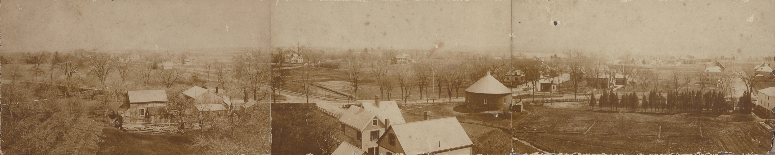
Dorchester Illustration no. 2309 Adams Corner circa 1877
The Dorchester Historical Society has received a set of three photographs from descendants of the Pierce family.
This photo came in three parts. The three photos appear to have been separate, mounted on card backing. It looks as if someone cut the card backing to allow the photos to be set side by side to create the wide landscape view that we have been able to achieve by scanning each one separately and combining the panels using Photoshop. A rough edge on the left panel indicates that there may once have been another panel to the very left.
The photo shows Adams corner between 1874 and 1882, before Gallivan Boulevard was created and when Marsh Street was a faint impression on the landscape leading toward the houses in the distance. The photographer was probably standing on Pierce land on the south side of what is now Beaumont Street up on the hill, somewhere about 53 to 71 Beaumont Street – in their backyards down toward Westmoreland Street, which did not exist at the time.
Adams Street runs horizontally from left to right, turning the corner around the coal gas building, continuing a block and passing the entrance to Malvern Street (now Millbrook Street), which extends vertically at the right side of the composite photo. Marsh Street runs from behind the coal gas round-house toward the houses in the distance. Granite Avenue runs diagonally to the right from that same intersection. The 1874 map indicates that the round house was owned by the Dorchester Gas Light Company, and continues to appear on the maps through 1910. Coal gas was used for illumination for street lights and residential and commercial buildings. The 1918 map shows the round house as a garage owned by Bernard Murphy.
The street extending from Adams Street in the center at an angle going off toward the left is Minot Street. Notice that on the near side of Adams Street between Minot Street and the coal gas house is a small stream that became larger as it went under Adams Street. This is the beginning of Davenport’s Creek leading to the Neponset River. A part of this stream is visible today as a gully on Hallett Street between the Firefighter’s Credit Union and the car dealership on the corner of Gallivan, although that location is not in this photo. I am told that the basements of houses along Minot Street are sometimes quite damp due to this underground stream. Between 1910 and 1918 the stream was capped from Adams Street to Ross Road. Between 1918 and 1933 the stream was capped as far as Hallet Street, probably as part of the construction of Gallivan Boulevard in the late 1920s.
The house in center in the distance is the S.S Pierce property whose site is now occupied by St. Brendan’s Church. The buildings in the left of the picture on the near side of Adams Street were the property of Thomas Pierce in 1874 and George Pierce in 1884.
On the 1874 map, the stream on the near side of Adams Street is visible, but Minot Street on the near side of Adams Street is only a proposed street. The bottom center of the photo shows a definite street on the near side of Adams and the upper portion of houses, so it would seem the photo is after 1874. The 1882 map shows Minot Street on near side of Adams Street, but the stream is no longer visible on the near side of Adams, so the stream must have been covered over in that eight year period. Therefore it seems the photo is earlier than 1882.